 2016-07-23 02:55:08 2016-07-23 02:55:08
|
Post #53
Re: 连载:与Kurt 划海洋冰川 -- 华人首次中型户 ... |
 kurtyang04 kurtyang04

|
Re: 连载:与Kurt 划海洋冰川 -- 华人首次中型户 ... pix13 |
|
kurtyang04 于 2016-07-27 03:10:28 编辑
|
|
|
2016-07-27 03:18:36
|
Post #54
Re: 连载:与Kurt 划海洋冰川 -- 华人首次中型户外探索阿拉 ... |
|
kurtyang04
|
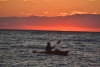
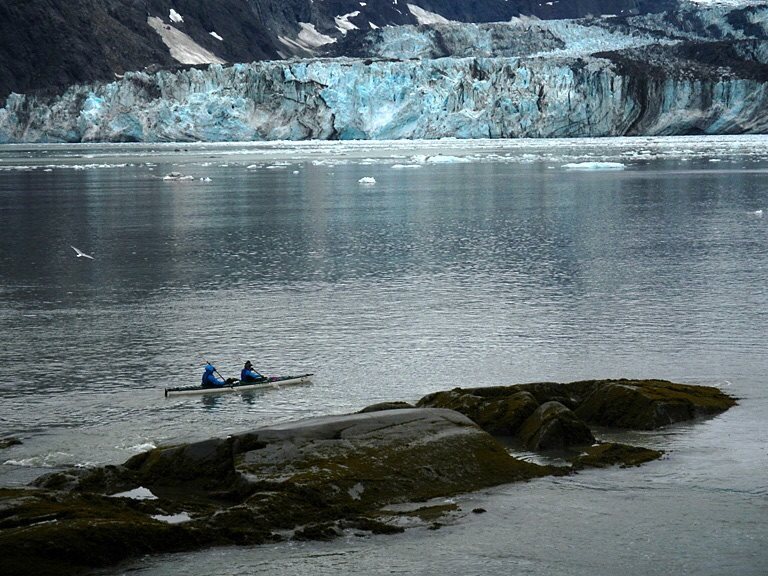
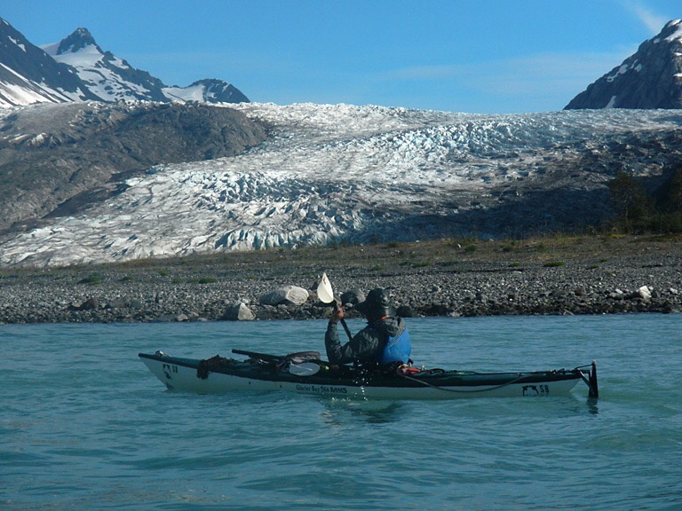
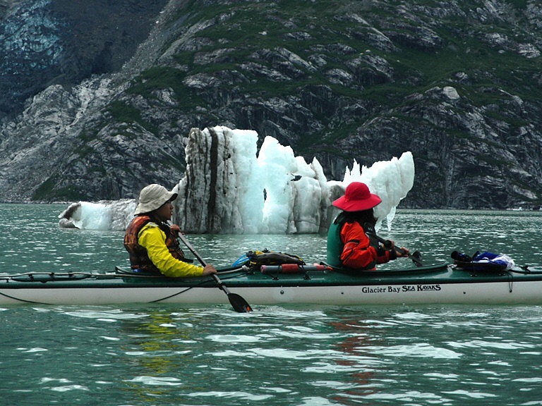
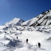
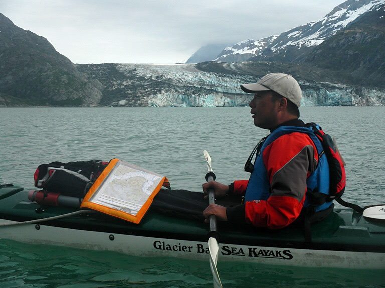
Many of Alaska most impressive glaciers end in the sea. Boats that berth in Whittier, Valdez, Seward, and Petersburg will take you to the tidewater termini of glaciers in PWS, Kenai Fjords, and Stephens passage. Cruise ships with population of small cities regularly glide into GB on their way up or down the Inside passage. Alternatively, you can climb into a kayak and spend a week or two paddling through the bergy bits and brash ice on you own. Nothing , absolutely nothing, will beat the view of Glacier from kayak seat, as your boat gently rocks on waves from the crashing iceberg. --- Mike Collier |
|
2016-07-27 03:40:35
|
Post #55
Re: 连载:与Kurt 划海洋冰川 -- 华人首次中型户外探索阿拉 ... |
|
kurtyang04
|
为什么阿拉斯加会那么多冰川呢? 加拿大和美国的北部好些地方比阿拉斯加一样冷,却没有冰川。 答案在于,雪雪雪!!! 阿拉斯加的天气雨多雪多,是出了名的。经常有各种风雪雨暴。 |
|
kurtyang04 于 2016-07-27 05:08:22 编辑
|
|
|
2016-07-27 04:32:36
|
Post #56
Re: 连载:与Kurt 划海洋冰川 -- 华人首次中型户外探索阿拉 ... |
|
kurtyang04
|
北美皮划艇探险协会是总部在波士顿华人为主的非盈利组织, 推动以中国人皮划艇在北美以及欧洲探险和交流,提供一种平台,推荐会员之间的AA制 探险活动,或者推荐接近商业但以非盈利为目的的探险活动。一个人在没有能力照顾自己或者提供团队责任前,AA是种不公平, 是不尊重皮划艇发展的规律。 而且美国皮划艇户外,存在半商业+半自主的探险, 正是体现一种公平和合理,这也是我们推荐尝试的模式一种。无论会员能力如何,我们将尽力谈判出成员很合理的价格, 完成一些皮划艇探险或旅行梦想。并通过一块出游,来减少旅行其他开支,同时结交户外大侠和其他品行良好的户外爱好者。 我们组织的基础是美国东北华人户外俱乐部,北美实力最强劲,十年的户外经验,400天以上活动,开创海外华人水上运动新纪元的组织,阿拉斯加的华人冰川海洋活动(2016),阿拉斯加首漂冰川河活动(2012),都是华人皮划艇探险运动的里程碑事件。并被中国权威 “户外”杂志 2015年7月刊当月最有影响的专题。 这将是有年费的公益组织,目前意向是100人民币每年,用于维护平台,并提供一些时间有限免费北美户外和旅行咨询服务。年费也是美国非盈利组织里,最低的收费标准。 本组织还没有正式开张,一些规章和策略在制定中。 我们接受的会员: 1 在北美居住,或经常出差来北美,或者有能力拿到北美旅游签证的朋友 2 喜欢皮划艇运动(无需经验),或者荒野户外,或者是对阿拉斯加和北极圈生态有浓厚兴趣朋友 3 热爱集体,敢于承担责任朋友,良好的集体精神,是户外活动的锦上添花。 这是初稿,8月底最后完成。有兴趣者,请加我微信:16176205369 |
|
2016-07-27 05:26:18
|
Post #57
Re: 连载:与Kurt 划海洋冰川 -- 华人首次中型户外探索阿拉 ... |
|
kurtyang04
|
说道阿拉斯加的天气,阿留申岛,有著名半持久的阿留申低气压,形成强大的逆时针旋转气流,这股气流把湿润的太平洋水分,推向北美的大陆,而北美大陆的雨暴大多与这个气流有关,是北美降雨的主要来源之一。 而这股超级湿流,首先在阿拉斯加碰到高山阻挡,于是气流最大的降雨发生在阿拉斯加的高山区。 最多的地方,一年降雨达 3米以上,降雪达30米以上。这是冰川的能量和物资的来源。 雪每年夏天可能融化,但是不是所有的雪融化, 不融化的雪就形成了冰川。 |
|
2016-07-28 01:07:50
|
Post #58
Re: 连载:与Kurt 划海洋冰川 -- 华人首次中型户 ... |
|
kurtyang04
|
熊是阿拉斯加荒野的象征,全程我们见到9只熊,距离不远,大多 15-40米远。 熊比想象地要萌,也非常激动人心。 见到5只棕熊,其中3只小小熊,这是我们在野外见到最萌的动物。 总体比德拉力国家公园的熊营养更好,更结实。 下面照片是借别人的,不过我们见到的小熊和图片一样萌,我们最担心的是熊来骚扰我们的帐篷,这事没有发生。 阿拉斯加最重要的动物标记就是熊的爪印,这个标记也是全球荒野的主要象征标记 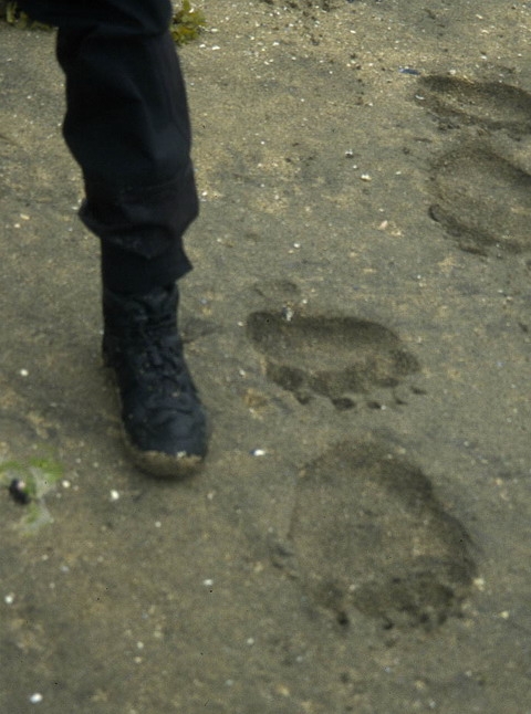 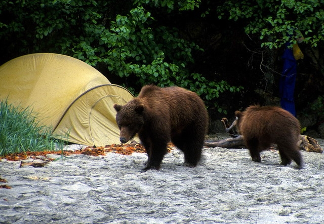 这次我们在划船路上见到了经典的熊站立姿态 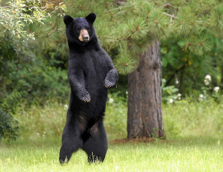
|
|
kurtyang04 于 2016-07-28 01:53:13 编辑
|
|
|
2016-07-28 01:26:51
|
Post #59
Re: 连载:与Kurt 划海洋冰川 -- 华人首次中型户外探索阿拉 ... |
|
kurtyang04
|
不是冰川都一样,冰川分热冰川,和冷冰川, 高山附近的冰川,和海洋附近的冰川有比较大的区别,它们形成,行为,和融化方式各不相同。 |
|
2016-07-28 05:52:19
|
Post #60
Re: 连载:与Kurt 划海洋冰川 -- 华人首次中型户 ... |
|
kurtyang04
|
发现有个台湾叫王盛熊几天后去了同样地方,他是白水大侠,可是跟guide, 去的,只有一张特别好照片。 为什么他们没去JH, 我发现他们有俩位老头老太,商业不能控制人的质量,和团队经验,难度和精彩度是商业的罩门,多少年前我就指出这点。哪怕带新人,我们对队员的训练和控制,是区别于商业的重要环节,也是我创造出的新模式。 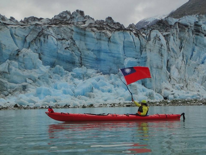
|
|
kurtyang04 于 2016-07-28 07:31:15 编辑
---------------------------------------- |
|
|
2016-07-28 08:52:46
|
Post #61
Re: 连载:与Kurt 划海洋冰川 -- 华人首次中型户 ... |
markka123456

|
支持北美皮划艇探险协会成立,希望能够一起能够参与探寻荒野秘境! |
|
---------------------------------------- |
|
|
2016-07-28 23:28:47
|
Post #62
Re: 连载:与Kurt 划海洋冰川 -- 华人首次中型户 ... |
|
kurtyang04
|
|
|
2016-07-29 01:47:49
|
Post #63
Re: 连载:与Kurt 划海洋冰川 -- 华人首次中型户 ... |
|
kurtyang04
|
Anatomy of a Glacier Glaciers form where more snow falls than melts. A glacier's accumulation area, located at higher elevations, accrues a wealth of snow and ice. The ablation area, located at lower elevations, loses ice through melting (downwasting) or calving. A glacier's terminus or face advances when more snow and ice amass than melt, and it retreats when melt exceeds accumulation. When melt equals accumulation, a glacier achieves equilibrium and its face remains stationary. Whether the glacier's face is advancing or retreating, glacial ice persistently glides down-valley. Coerced by gravity, ice pursues the path of least resistance. Ice depth and bedrock angle influence the rate of glacial flow. Glaciers contain two zones of ice flow. The zone of plastic flow, ice closest to the bedrock, experiences extreme pressure from the weight of the ice above and conforms to the anomalies in the bedrock. The zone of brittle flow, the upper 150 feet of glacial ice, lacks this pressure and reacts in-elastically to the bedrock features, forming elongated cracks called crevasses which fluctuate with the glacier's flow. Tubular chutes or moulins drain surface meltwater, and formidable spires of ice called seracs reach skyward. Ice plummets over particularly steep terrain creating ice falls. One theory suggests that differences in seasonal flow rates over an icefall create the convex bands called ogives at the base of the falls, which undulate down glacier. The erosive power of glacial flow changes the landscape and scrapes much of the soil and rock from the valley walls that channel its irrepressible flow. 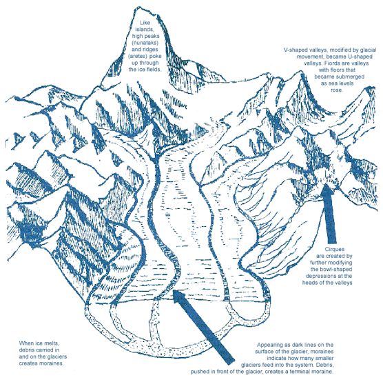 Glacier Footprints Glaciers leave an impressive footprint on the landscape, carving the rock as they retreat and leaving behind steep topography and fiords where the ice once held sway. Flooded seacoasts and rising water levels are the legacy of their retreats, as are the ecological changes on the landscapes around the glacier's edge. Glaciers also have cultural impacts, in that their activity has affected human settlement, migration, and subsistence over thousands of years. The landscape around a glacier clearly illustrates the effects of Pleistocene and Holocene glaciation. Ice excavates the bedrock, forming bowl-shaped cirques, pyramidal horns, and a series of jagged spires called arête ridges that separate glacial valleys. As glaciers carve U-shaped valleys, rocks plucked from the bedrock and frozen in the ice etch grooves and striations in the bedrock. Rocks scoured from surrounding valley walls create dark debris lines called lateral or medial moraines along the edges and down the center of glaciers. Pulverized rock called rock flour, ground by the glacier to a fine powder, escapes with glacial meltwater producing the murky color of glacially fed rivers and lakes. Glacial recession unmasks trimlines, slightly sloping changes in vegetation or weathered bedrock on the valley walls that indicate a glacier's height at its glacial maximum. Meltwater transports glacially eroded material to the outwash plain, an alluvial plain at the edge of retreating glaciers. Icebergs break away or calve from the faces of glaciers ending in lakes or the ocean. Cracked pieces of rock, plucked or torn from the bedrock, are carried with other debris in and on the glacier. This debris scrapes the valley walls and floors, leaving grooves and striations. Rock debris is crushed and ground into fine grains, called rock flour |
|
2016-07-29 01:59:08
|
Post #64
Re: 连载:与Kurt 划海洋冰川 -- 华人首次中型户外探索阿拉 ... |
|
kurtyang04
|
A glacier has two main sections: the accumulation zone and the ablation zone. High in the mountains, a glacier forms as snow accumulates and compresses first into “firn,” a granular ice, and then finally into glacial ice. A glacier begins to move, or “flow,” as it acquires more and more mass. When it moves south to warmer temperatures, the foot of the glacier will slough off – giant pieces break and melt. This area where a glacier loses mass is the ablation zone. The boundary between the two zones, the equilibrium line, adjusts with the seasons. In warmer periods, the ablation zone is larger and the equilibrium line moves further up the glacier. When it’s colder, the accumulation zone is larger. And when the two areas are roughly equal, the glacier is considered stable.
|
|
2016-07-29 02:06:52
|
Post #65
Re: 连载:与Kurt 划海洋冰川 -- 华人首次中型户外探索阿拉 ... |
|
kurtyang04
|
冰川有两个主要部分:积累区和消融区。在高山,雪积累和压缩成第一“积雪”,颗粒状冰块,然后最后进入冰川冰川的形式。冰川开始移动,还是“流”,因为它获得越来越多的重量。当它向南移动到气温升高,冰川脚下就会脱落 - 巨人打碎融化。这个区域,冰川失去质量消融区。这两个区域的平衡线,之间的边界随季节调整。在温暖的时期,消融区较大,平衡线进一步向上移动的冰川。当它的较冷的,积累区较大。而当两个区域大致相等,冰川被认为是稳定的。 |
|
2016-07-29 09:16:42
|
Post #66
Re: 连载:与Kurt 划海洋冰川 -- 华人首次中型户外探索阿拉 ... |
剪刀手

|
酷!!! |
|
2016-07-29 09:27:55
|
Post #67
Re: 连载:与Kurt 划海洋冰川 -- 华人首次中型户外探索阿拉 ... |
年糕卷儿

CP是梭子蟹~ |
强科普帖,帮顶~ |
|
---------------------------------------- |
|
|
2016-07-29 09:31:45
|
Post #68
连载:与Kurt 划海洋冰川 -- 华人首次中型户外探索阿拉斯加 ... |
|
kurtyang04
|
|
|
kurtyang04 于 2016-08-02 04:03:32 编辑
|
|
|
2016-07-30 10:13:09
|
Post #69
Re: 连载:与Kurt 划海洋冰川 -- 华人首次中型户 ... |
黄果

历史、美食、旅游 ... 
|
精华之 |
|
---------------------------------------- |
|
|
2016-07-30 23:13:21
|
Post #70
Re: 连载:与Kurt 划海洋冰川 -- 华人首次中型户 ... |
岭南一石

行作笔 心当墨
|
完美!回归自然回归简单,无动力,环保,皮划艇是最高尚的水上运动之一! |
|
---------------------------------------- |
|
|
2016-07-31 23:46:35
|
Post #71
连载:与Kurt 划海洋冰川 -- 华人首次中型户外探索阿拉斯加 ... |
|
kurtyang04
|
秒杀超级豪华邮轮和普通油轮,差得不是一档两挡,而是爬珠峰与飞机看珠峰的区别 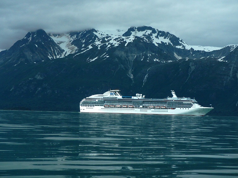
|
|
kurtyang04 于 2016-08-02 04:03:08 编辑
|
|
|
2016-08-02 05:57:08
|
Post #72
Re: 连载:与Kurt 划海洋冰川 -- 华人首次中型户 ... |
|
kurtyang04
|
冰川是根据短期的温度,和降雨(雪),气候的长期变化 在持续变化动态中。 冰川有三样东西组成:冰川冰,沉积物,以及冰河流动经过的河床。 |
|
2016-08-02 06:02:15
|
Post #73
Re: 连载:与Kurt 划海洋冰川 -- 华人首次中型户外探索阿拉 ... |
|
kurtyang04
|
Glacier ice is actually a mono-mineralic rock (A rock made of only one mineral, like limestone which is composed of the mineral calcite.) The mineral ice is the crystalline form of water (H2O). It forms through the metamorphism of tens of thousands of individual snowflakes into crystals of glacier ice. Each snow flake is a single, six-sided (hexagonal) crystal with a central core and six projecting arms. The metamorphism process is driven by the weight of overlying snow. During metamorphism, hundreds, if not thousands of individual snowflakes recrystallize into much larger and denser individual ice crystals. Some of the largest ice crystals observed at Alaska’s Mendenhall Glacier are nearly one foot in length. 冰川实际上是一个单矿物质岩石(仅由一种矿物的岩石,例如它是由矿物方解石石灰石)的矿物冰的水(H2O)的结晶形式。它通过形成数以万计的个人雪花的变质成冰川的结晶。每个雪花是一个单一的,六面(六边形)晶体具有中心芯和六个突出臂。变质过程是由覆雪的重量驱动。在变质,数百,甚至数千个雪花的再结晶成更大和更密集的个体冰晶。一些在阿拉斯加的门登霍尔冰川观测到的最大冰晶的长度将近一英尺。 |
|
2016-08-02 06:07:12
|
Post #74
Re: 连载:与Kurt 划海洋冰川 -- 华人首次中型户 ... |
|
kurtyang04
|
Glacial deposits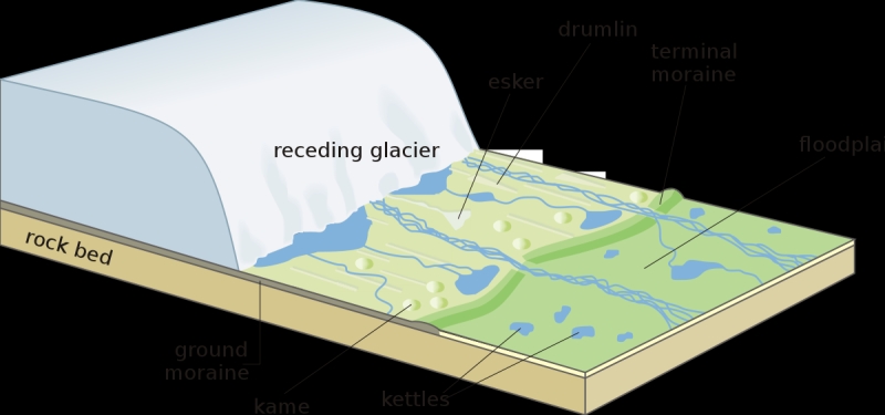 Landscape produced by a receding glacier When a glacier's size shrinks below a critical point, its flow stops and it becomes stationary. Meanwhile, meltwater within and beneath the ice leaves stratified alluvial deposits. These deposits, in the forms of columns, terraces and clusters, remain after the glacier melts and are known as "glacial deposits". Glacial deposits that take the shape of hills or mounds are called kames. Some kames form when meltwater deposits sediments through openings in the interior of the ice. Others are produced by fans or deltas created by meltwater. When the glacial ice occupies a valley, it can form terraces or kames along the sides of the valley. Long, sinuous glacial deposits are called eskers. Eskers are composed of sand and gravel that was deposited by meltwater streams that flowed through ice tunnels within or beneath a glacier. They remain after the ice melts, with heights exceeding 100 meters and lengths of as long as 100 km. |
|
2016-08-02 06:15:06
|
Post #75
Re: 连载:与Kurt 划海洋冰川 -- 华人首次中型户外探索阿拉 ... |
|
kurtyang04
|
当一个冰川的尺寸收缩低于一个临界点时,其流动停止,并且变得平稳。同时,内部和下方的冰融水叶分层冲积矿床。这些沉积物,在列,露台和簇的形式,保持在冰川融化后,被称为“冰沉积”。 称取山丘或土堆的形状冰川沉积物被称为kames。一些kames形成时融水沉积物的沉积物通过在冰的内部开口。其他人则通过融水产生的风扇或三角洲效应产生。当冰川占据一个山谷,它可以形成沿山谷两侧露台或kames。 龙,蜿蜒的冰碛物被称为eskers。 Eskers是由砂石,是由通过冰隧道内或冰川下的融水流入流沉积。它们保持在冰融化后,用高度超过100米,最长达100公里长度。 |
|
2016-08-03 11:28:10
|
Post #76
Re: 连载:与Kurt 划海洋冰川 -- 华人首次中型户 ... |
麻烦的星星
好麻烦啊 |
多谢楼主科普,涨姿势! |
|
---------------------------------------- |
|
|
2016-08-03 15:26:07
|
Post #77
Re: 连载:与Kurt 划海洋冰川 -- 华人首次中型户外探索阿拉 ... |
磨小编

磨房小编辑•̀ᴗ•́
|
感谢分享,已推荐至磨房首页。
|
|
---------------------------------------- |
|
邀请xuliang1215参加此活动


 分享
分享
